
5 Reliable Spots for Hunting Ducks in Michigan
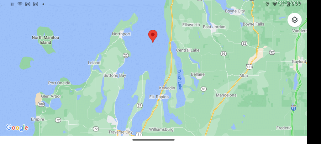
Grand Traverse Bay
Grand Traverse Bay is in the Northeast end of Lake Michigan. It and the area around it has a huge amount of public water open to hunting. Not only is it some of the most beautiful territory in the state, it’s also very productive for waterfowl.
It’s in the Northwest corner of Michigan’s southern peninsula. This area has both huge open waters and small lakes and coves which make it a perfect area for ducks all season long.
The bay itself is a big, somewhat windy area that’s not well suited to small watercraft. You can certainly hunt in a boat, just consider the size of the water you will be on. The weather can change quickly out there.
In the bay, you will get lots of divers, coots, and the classic mallards. As you get closer to the big water you will see more and more variety in the waterfowl. It’s part of the primary channel of the migration flyway. Besides local ducks, there will be a lot of ducks coming out from Canada and northern Michigan.
Personally, I don’t really like hunting in the wide-open water. I’ve heard too many stories and I don’t have a boat that can handle 6-foot waves that are not uncommon. I can take my canoe and go into the smaller areas and still hunt just fine.
Besides the big bay, you can hunt the smaller lakes. I’d prefer to put my boat in torch River at the access just off of Aarwood Drive, then go downriver into Skegmog Lake. For the record, it’s a no-wake river.
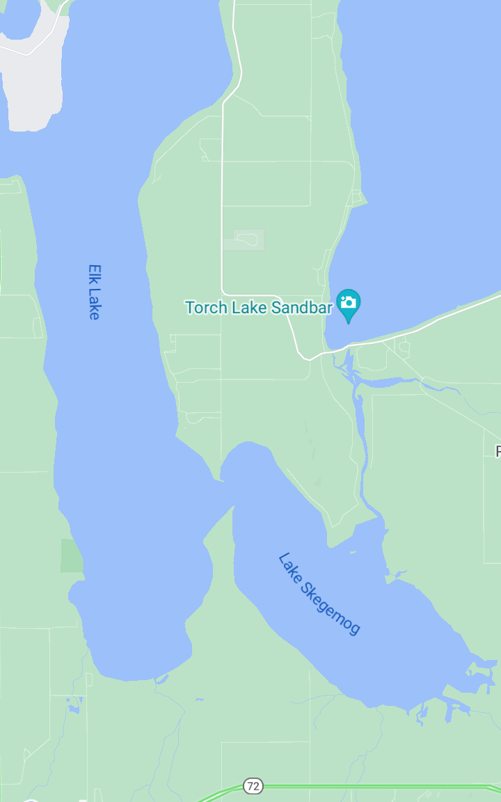
Skegmog Lake is a nice one for smaller boats and even kayaks. Skegmog is largely a floodway created by the dem at Elk Rapids, right between Elk Lake and Lake Michigan. The east side of the lake is mostly flooded cedar stumps from ages ago.
It can be completely full of ducks at times and catches a lot of overhead flyers. There’s also some decent cover for a floating blind. The whole west shoreline is a public wildlife area, and a swamp. There is a lot of area there for decoy spreads. Sometimes the waves get 3 or 4-feet, but if you stick to the shallows, it will be fine.
This place is awesome for duck hunting. There’s a lot of boat traffic in warm weather, but that’s done well before the October season opener. As far as local amenities, there is everything you could want on the south end of the bay, in Traverse City.
I’m gonna throw in one little sneaky spot. Right near the bay, there’s the Petobego State Game Area. It’s a great swampy pond. State Game Areas have no access fees or permits. Just follow the rules and keep it clean. I’ll share a link to the map with all the state land rules. Here it is.
Luddington
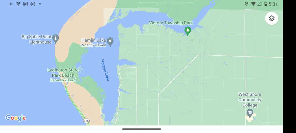
About 80 miles south down the Michigan shoreline from Grand Traverse is Luddington. The town of Luddington has a big state park, that’s open to hunting. It also has a state campground and a beautiful lake, Hamlin Lake.
Hamlin Lake is a classic destination for duck hunters looking for an easy access “up north hunt”. The campground is open year-round. I’ve been up there in November before, just before freeze-up. The water was cold, but I did manage to get a few divers and catch some Northern Pike.
I would advise against staying in the campground in early October because it’s so darn full of tourists wanting to see the fall colors. Hamlin Lake is a place where you can get large flocks of ducks anytime the water is open, but mid-season is often the best time in my opinion.
That’s around Late October to early November. Although, it does really depend on how early the flocks start moving through on their migration.
There’s a public boat launch at the north end of the lake, But I prefer to just carry my canoe from the state campground. Let me tell ya, there’s not much better than sitting by the campfire after a chilly evening hunt on the lake.
Ludington has a number of inexpensive motels, several big grocery stores, and a nice baptist church if you feel so inclined. There is a little party store after leaving the city, just before getting to the campground. I know the guy who owns it. He sells firewood and some camping basics.
Luddington is the kind of place you could bring the whole family to. The state park has some nice hiking trails that go along the forest and dunes. There’s a great view of the old lighthouse, and the river at the south end of the park is a hot spot for fishermen during the fall salmon run.
Here’s a link to a map of the public land, and here’s a link to a map of Hamlin Lake
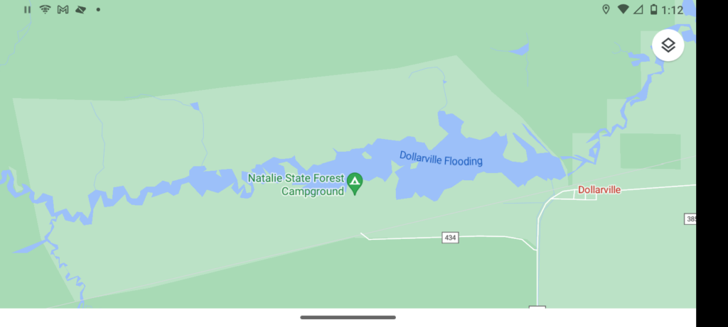
Dollarville Flooding
Dollarville is a tiny town in the middle of the Upper Peninsula or UP. If you’re not from around here, we don’t call it the northern peninsula. It’s the UP and the folks up there are Yoopers.
The Dollarville Flooding sits on the Tahquamenon River. It’s the result of an old dam. If you want some true “up north” hunting, this is it. It’s hardly a town really. Dollarville is a mile west of the town of Newberry. Newberry is where You’ll find an assortment of restaurants and grocery stores.
The Dollarville Flooding is a mid-sized lake in a state-managed public game/hunting area. It’s about 1,400 acres of water that you can easily navigate in a motorized boat.
This is a favorite hunting spot for locals. The Flooding is about three miles long and wide enough for hunters on both sides of the shore in a lot of the area. It’s marshy and dotted with small coves and islands. There is a nice parking lot on the south side of the Flooding
This is a great spot for both open water hunting, and shoreline hunting. Ducks of all shapes and sizes are not uncommon, but there are fewer divers here since it’s a ways from the big waters. Wood ducks, teal, and mallards are fairly common. As are both the Canadian and Richardson goose.
The water gets fairly deep to the east near the dam but is generally boatable for a good three miles or more. It’s good fishing water for walleye, pike and muskellunge. So, if hunting is slow, there’s always that.
There isn’t one set of techniques that work best here. Some will shore hunt and set up a decoy spread in the first 15-30-yards of water. Some like to hunt in the open water I much prefer shore hunting because it’s so darn easy to hide, and you’ll stay dry.
On the south side of the flooding is a small state campground and boat launch. You will need a State Park Pass to use either. rules will be posted on the big wooden bulletin board in the camp. It’s a very rustic camp, but it does have some running water before winter comes. This place is never crowded.
This is one of the spots I’m planning on going to next season. If you see an old, white canvas wall tent with an American flag out front, it’s likely me.
Here’s a link to a great map of the area.
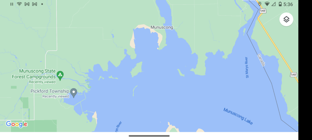
Munuscong Bay
Munuscong Bay is where the small, dark-watered Munuscong River meets the blue water of the Saint Marry’s river. While part of the Saint Mary’s river, the wide body of water is known as Munuscong Lake. You’ll find it on the east end of the UP.
The “bay” is the west side of the lake. The east shoreline and the shallow water near it are part of Canada. Besides the bay, there are around two miles along both sides of the Munuscong river that is public hunting land.
This place is the corner between three of Michigan’s Great Lakes. there are a lot of divers in Munuscong. But, also every other migrating waterfowl. You can literally get everything coming through in the course of a few days.
Munuscong is one of those true Yooper towns. There’s not much around, but trees, water, and cold wind. It’s the second most famous duck hunting spot in Michigan. and we have a lot of options here.
Most hunters stay to the west side because it’s got the best territory for ducks. I will tell you that it gets cold and windy here. You’re gonna want a good hat and windproof jacket during the hunt.
The state forest has a rustic campground, several gravel parking lots, and a boat launch in the river. Along the south shore of the water, there is a restaurant, gas station, hotel, and a small grocery store.
Here’s a map of the Munuscong River State Game Area
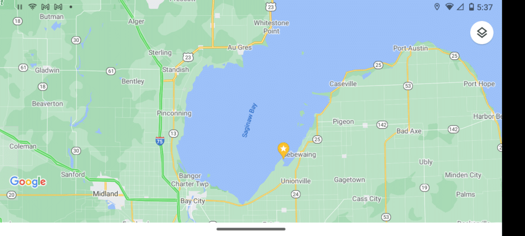
Saginaw Bay
Saginaw bay is the crest of all duck hunting in Michigan. It’s the one spot that’s known by a lot of out-of-staters. It’s a humungous bay full of inlets, outlets, and old port towns. Saginaw bay is the primary hunting area in this side of the Mississippi Flyway (where migrations come through).
Most of the hunting is done within a mile of the shoreline. A lot of hunters stick to the open water, but quite a few hunt the marshland and mudflats which run along the outline of the entire bay.
The only problem with hunting along the shoreline is that it’s full of marsh reeds that grow up to 10 feet tall. I’ve never had a problem seeing and hitting birds there, there are plenty of them. but I have had a horrible time finding downed birds. If you don’t have a retrieving dog, you better stick to the water.
One thing about the bay is that it’s fairly shallow. at times, we’ve been able to walk out several miles wearing waders and not get wet. It’s a shallow bay.
That shallow water can get dangerous too. During bad weather, you can get waves that rise up 3 or 4 feet. the problem is that after riding the crest of a wave, your boat can drop down so low that the transom smacks the ground beneath.
Many boats have been split on the bay from those deadly waves. There are always people being stranded in small boats after hitting the rocky bottom. It often shears the pin or breaks the prop on the outboard. My uncle went through 4 shear pins just trying to make it back to shore before the storm got bad.
Saginaw Bay can be a great place. Just watch the weather and if something is moving in, maybe stay close to shore. keep an extra prop and several extra shear pins too. even in fairly smooth water, you can easily hit one of the many rocks or accidentally stray into shallow water.
There are a good number of blinds in the bay. They were built by local hunters, but state law says they are public property on a first come first serve basis. If you do use one, be courteous. If the guy who built the blind cones up to hunt it, let him have it.
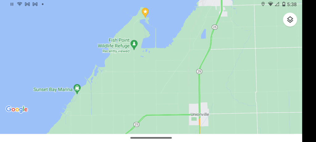
The area in the bay that I have experience in is Fish Point. This is another one of my sneaky spots. right along the edge of Fish Point is a large wetland preserve managed by the state. By hunting in the marsh just past the preserve, I can always get a decent morning hunt.
On the top left side of the map, (bottom of this section), you’ll see a small black square and triangle representing a parking lot and boat launch. There is a trail from there going into the marsh at the edge of the bay. That’s how I get out to the marshland. I’ve had good luck by finding a semi-clear spot near the edge and setting up two Mojo decoys.
Also, in most of the marsh, decoys, including spinning wings like the Mojo may not be visible due to the reeds. I did see one hunter with a homemade 10-foot extension on his Mojo. If you know a metal worker, I’m sure they could make something like that for you.
Fish Point is also home to the Fish Point Managed Hunt Area. It’s a series of ponds and grain fields that are flooded and sectioned off into separate hunting fields. There are daily drawings for both morning and evening hunts.
We refer to this as Duck Bingo. The first few hunts of the year have 2 drawings. Enter by mail and if selected, you’re in the drawing for a hunt of a lifetime and guaranteed a spot. After the opener, you just show up, enter, and see if you get a spot.
There are seven draw areas in Michigan, and this one is the best. There are also handicap-accessible blinds with boat access. The only downside to this is that it can be high-stress and confusing at first. At the Fish Point draw area, there is a limited number of fields available to single hunters.
Most of the fields are reserved for parties of 2-4 hunters. There is plenty of room in each field for 4 hunters. Often, we’ll try the draw first and if we don’t get picked, we go out to the bay marsh.
Here’s the map of Fish Point